Sea Routes#
This notebook cleans and processes maritime routes from Mariquant (2019) made available in the following S3 links:
Setup#
import pandas as pd
import geopandas as gpd
from os.path import join, expanduser
from shapely.geometry import Point
from shapely.wkt import loads
from shapely.geometry import LineString, MultiLineString

pd.set_option("display.max_columns", None)
import sys

gn_path = join(expanduser("~"), "Repos", "GOSTnets")
sys.path.append(gn_path)
import GOSTnets as gn
import osmnx as ox
import pickle
import numpy as np
import matplotlib.pyplot as plt
%load_ext autoreload
%autoreload 2
Load Datasets#
routes_dir = join(expanduser("~"), "tmp", "sea_routes")
ports = pd.read_csv(join(routes_dir, "ports.csv"), index_col=0)
distances = pd.read_csv(join(routes_dir, "distances.csv"), index_col=0)
routes = pd.read_csv(join(routes_dir, "routes.csv"), index_col=0)
from pandarallel import pandarallel

pandarallel.initialize(progress_bar=False, nb_workers=60)
INFO: Pandarallel will run on 60 workers.
INFO: Pandarallel will use Memory file system to transfer data between the main process and workers.
routes.loc[:, "geometry"] = routes.parallel_apply(
    lambda x: Point(x["lon"], x["lat"]), axis=1
)
routes = gpd.GeoDataFrame(routes, geometry="geometry", crs="EPSG:4326")
routes.head(3)
| trip_count | prev_port | next_port | lat | lon | frequency | geometry | |
|---|---|---|---|---|---|---|---|
| 7641 | 1984063 | 4410 | 3658 | 45.764835 | -87.053288 | 1.0 | POINT (-87.05329 45.76483) |
| 7642 | 1984063 | 4410 | 3658 | 45.608533 | -87.038217 | 1.0 | POINT (-87.03822 45.60853) |
| 7643 | 1984063 | 4410 | 3658 | 45.560133 | -87.034233 | 1.0 | POINT (-87.03423 45.56013) |
routes.loc[routes.trip_count == 793298]
| trip_count | prev_port | next_port | lat | lon | frequency | geometry | |
|---|---|---|---|---|---|---|---|
| 10505995 | 793298 | 842 | 1594 | 39.996088 | 26.134098 | 0.02 | POINT (26.13410 39.99609) |
| 10505996 | 793298 | 842 | 1594 | 40.011167 | 26.160333 | 0.02 | POINT (26.16033 40.01117) |
routes.loc[routes.trip_count == 793574]
| trip_count | prev_port | next_port | lat | lon | frequency | geometry | |
|---|---|---|---|---|---|---|---|
| 10506002 | 793574 | 2866 | 842 | 51.334010 | 3.787823 | 0.02 | POINT (3.78782 51.33401) |
| 10506003 | 793574 | 2866 | 842 | 40.013000 | 26.160500 | 0.02 | POINT (26.16050 40.01300) |
| 10506004 | 793574 | 2866 | 842 | 39.996088 | 26.134098 | 0.02 | POINT (26.13410 39.99609) |
distances.loc[distances.trip_count == 793298]
| trip_count | prev_port | next_port | distance | frequency | |
|---|---|---|---|---|---|
| 10505997 | 793298 | 2866 | 842 | 3.015057 | 0.02 |
routes.loc[(routes.prev_port == 2866) & (routes.next_port == 842)][
    "trip_count"
].unique()
array([ 791366,  791569,  791704,  793090,  793161,  793163,  793404,
        793574,  793601, 2676969])
ports.loc[:, "geometry"] = ports.apply(lambda x: Point(eval(x.coords)[0]), axis=1)
ports = gpd.GeoDataFrame(ports, geometry="geometry", crs="EPSG:4326")
ports.head(2)
| PORT_NAME | INDEX_NO | coords | geometry | |
|---|---|---|---|---|
| 49159 | Terminal Pesquero Cta. Quiane | NaN | ((-70.31722387298942, -18.513597026467323),) | POINT (-70.31722 -18.51360) |
| 49164 | Oil Berth | NaN | ((-61.86886473007713, 17.150384410999997),) | POINT (-61.86886 17.15038) |
distances.head(2)
| trip_count | prev_port | next_port | distance | frequency | |
|---|---|---|---|---|---|
| 7682 | 1984063 | 4410 | 3658 | 460.638148 | 1.0 |
| 7062 | 1948666 | 3658 | 7083 | 372.753814 | 1.0 |
Merge Routes with Geometry#
Clean Geometries#
Split geometry if it passes the international dateline (180 longitude)
pdc = "EPSG:3832"
wgs = "EPSG:4326"
azimuthal = "ESRI:54032"
rob = "ESRI:54030"
# check if signs of two numbers are different
def sign_diff(a, b):
    return a * b < 0


# split coords by dateline crossing
def split_coords(coords):
    # coords = list(coords)
    xs = [coord.x for coord in coords]
    xs_ = np.sign(xs)

    groups = []
    g = 0
    for i, x in enumerate(xs_):
        groups.append(g)
        if i + 1 == len(xs_):
            break
        else:
            if x != xs_[i + 1]:
                g += 1

    components = []
    for group in np.unique(groups):
        g_mask = [g == group for g in groups]
        comp = coords[g_mask]
        if len(comp) > 1:
            components.append(comp)

    return components


def get_line(row):
    route = routes.loc[
        (
            (routes["trip_count"] == row.trip_count)
            & (routes["prev_port"] == row.prev_port)
            & (routes["next_port"] == row.next_port)
        )
    ].copy()
    if len(route) > 1:
        coords = route.geometry.values
        xs = [coord.x for coord in coords]
        # check if route crosses dateline
        n_components = 1
        if sign_diff(np.min(xs), np.max(xs)) and (
            (np.abs(np.min(xs)) + np.abs(np.max(xs))) > 180
        ):
            components = split_coords(coords)
            if len(components) == 1:
                geom = LineString(components[0])
            elif len(components) > 1:
                n_components = len(components)
                geom = MultiLineString(components)
            else:
                geom = None
                n_components = 0
        else:
            geom = LineString(coords)
        return (geom, n_components)
    else:
        return (None, 0)
distances = distances.loc[(distances.prev_port != distances.next_port)].copy()
len(distances)
54464
# route = routes.loc[((routes["trip_count"] == row.trip_count) & (routes["prev_port"] == row.prev_port) & (routes['next_port'] == row.next_port))].copy()
# for idx, row in tqdm(distances.iterrows()):
#     geom, n_components = get_line(row)
#     distances.loc[idx, "geometry"] = geom
#     distances.loc[idx, "n_components"] = n_components
# d = distances.head(100)
# d
res = distances.parallel_apply(lambda x: get_line(x), axis=1, result_type="expand")
res.rename(columns={0: "geometry", 1: "n_components"}, inplace=True)
res
| geometry | n_components | |
|---|---|---|
| 7682 | LINESTRING (-87.05328753692308 45.764835, -87.... | 1.0 |
| 7062 | LINESTRING (-87.49138600094876 41.674835, -87.... | 1.0 |
| 2712 | LINESTRING (-83.98649742848713 46.056966407419... | 1.0 |
| 7248 | LINESTRING (-84.24103337782078 46.401167342082... | 1.0 |
| 9021 | LINESTRING (-84.37628495982278 46.51214, -84.3... | 1.0 |
| ... | ... | ... |
| 14004962 | LINESTRING (129.4345365315 35.420577800000004,... | 1.0 |
| 14005987 | LINESTRING (140.83933433227966 51.461370019242... | 1.0 |
| 14006777 | LINESTRING (140.7279770176368 35.9373607719317... | 1.0 |
| 14006449 | LINESTRING (129.4414099450023 35.4347456475, 1... | 1.0 |
| 14006517 | LINESTRING (140.83933433227966 51.461370019242... | 1.0 |
54464 rows × 2 columns
distances = distances.join(res)
distances = distances.loc[distances.n_components > 0].copy()
distances.to_csv(join(routes_dir, "distances_processed_v2.csv"), index=False)
# distances = pd.read_csv(join(routes_dir, "distances_processed_v2.csv"))
distances_filt = distances.loc[~(distances.geometry.isna())].copy()
distances_filt.loc[:, "geometry"] = distances_filt.apply(
    lambda x: loads(x.geometry), axis=1
)
ports.reset_index(inplace=True)
distances_filt.n_components.value_counts()
n_components
1.0    51962
2.0     1705
4.0        2
3.0        2
Name: count, dtype: int64
distances = distances_filt.copy()
Clean Rotues#
Remove routes with too many segments
distances = distances.loc[distances.n_components < 3].copy()
distances = gpd.GeoDataFrame(distances, geometry="geometry", crs=wgs)
Remove long routes that intersect land (likely errors)
land = gpd.read_file(join(expanduser("~"), "tmp", "ne", "ne_50m_land.shp"))
land_geom = land.unary_union
def get_intersect_pct(geom):
    if geom.intersects(land_geom):
        length = geom.length
        length_land = geom.intersection(land_geom).length
        return length_land / length
    else:
        return 0
distances.loc[:, "land_intersect"] = distances.parallel_apply(
    lambda x: get_intersect_pct(x.geometry), axis=1
)
distances.land_intersect.describe()
count    53667.000000
mean         0.060815
std          0.195913
min          0.000000
25%          0.000000
50%          0.000135
75%          0.007999
max          1.000000
Name: land_intersect, dtype: float64
len(distances.loc[distances.land_intersect > 0.5])
2504
intersect_thresh = 0.1
length_thresh = distances.length.median()  # 10 #
distances2 = distances.loc[
    ~(
        (distances.land_intersect > intersect_thresh)
        & (distances.length > length_thresh)
    )
].copy()
/tmp/ipykernel_4000684/2524201493.py:2: UserWarning: Geometry is in a geographic CRS. Results from 'length' are likely incorrect. Use 'GeoSeries.to_crs()' to re-project geometries to a projected CRS before this operation.

  length_thresh = distances.length.median()  # 10 #
/tmp/ipykernel_4000684/2524201493.py:6: UserWarning: Geometry is in a geographic CRS. Results from 'length' are likely incorrect. Use 'GeoSeries.to_crs()' to re-project geometries to a projected CRS before this operation.

  & (distances.length > length_thresh)
len(distances2)
52581
distances2.loc[:, "index"] = distances2.index
def get_n_vertices(row):
    if type(row.geometry) == LineString:
        return len(row.geometry.coords)
    elif type(row.geometry) == MultiLineString:
        return sum([len(line.coords) for line in row.geometry.geoms])
# row = distances2.loc[1390]
# row = distances2.iloc[0]
# get_n_vertices(row)
# distances2.[:, "n_vertices"] = distances2.parallel_apply(get_n_vertices, axis=1)
distances2.loc[:, "n_vertices"] = distances2.apply(get_n_vertices, axis=1)
# distances2.to_file(join(routes_dir, "distances2.gpkg"), driver="GPKG")
distances2["n_vertices"].describe()
count    52581.000000
mean       204.802704
std        302.280853
min          2.000000
25%         24.000000
50%         81.000000
75%        247.000000
max       3156.000000
Name: n_vertices, dtype: float64
distances2 = distances2.loc[distances2["n_vertices"] > 5].copy()
to_remove = [51240, 19656, 43777, 44592, 27546, 40347, 30619, 43181, 6817, 19896]
# distances2.loc[51240]
distances2.loc[(distances2["index"].isin(to_remove))]
| trip_count | prev_port | next_port | distance | frequency | geometry | n_components | land_intersect | index | n_vertices |
|---|
distances2 = distances2.loc[~(distances2["index"].isin(to_remove))].copy()
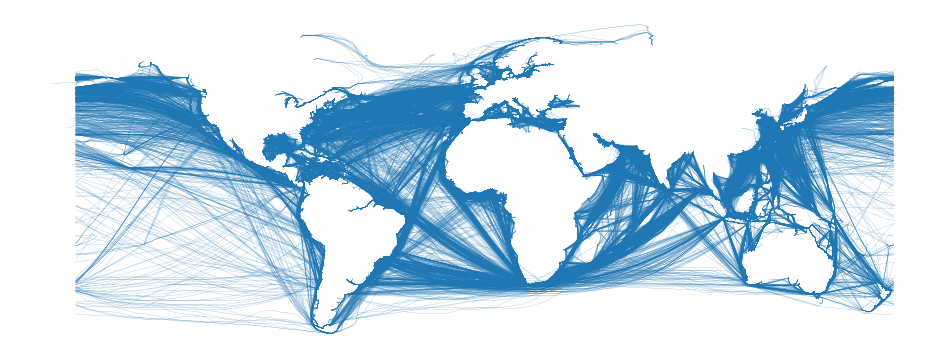
Plot Routes#
fig, ax = plt.subplots(figsize=(12, 14))
distances2.plot(ax=ax, linewidth=0.1)
plt.axis("off")
(-208.73408508695817, 200.2372267536647, -62.9315025035, 83.9357858335)
ports.head()
| index | PORT_NAME | INDEX_NO | coords | geometry | |
|---|---|---|---|---|---|
| 0 | 49159 | Terminal Pesquero Cta. Quiane | NaN | ((-70.31722387298942, -18.513597026467323),) | POINT (-70.31722 -18.51360) |
| 1 | 49164 | Oil Berth | NaN | ((-61.86886473007713, 17.150384410999997),) | POINT (-61.86886 17.15038) |
| 2 | 16 | Port of Basamuk | NaN | ((146.14295817405977, -5.53913255687803),) | POINT (146.14296 -5.53913) |
| 3 | 26 | Victoria | NaN | ((-123.32715191091728, 48.402783083729446),) | POINT (-123.32715 48.40278) |
| 4 | 34 | NaN | NaN | ((126.50786074843957, 36.333661512471735),) | POINT (126.50786 36.33366) |
len(distances2.loc[distances2.land_intersect == 1])
924
# distances2.loc[distances2.land_intersect ==1].explore()
# import git
# import os
# git_repo = git.Repo(join(expanduser("~"), "Repos", "red-sea-monitoring", "notebooks"), search_parent_directories=True)
# git_root = git_repo.git.rev_parse("--show-toplevel")
# sys.path.append(join(git_root, "src"))
# from red_sea_monitoring.utils import *
# chokepoints = get_chokepoints()
# chokepoints.loc[:, "geometry"] = chokepoints.apply(
#     lambda x: Point(x.lon, x.lat), axis=1
# )
# chokepoints = gpd.GeoDataFrame(
#     chokepoints, geometry="geometry", crs="EPSG:4326"
# )
# # List areas of interest
# aois = ["Bab el-Mandeb Strait", "Cape of Good Hope", "Suez Canal", "Strait of Hormuz"]
# azimuthal = "ESRI:54032"
# chokepoints_sel = chokepoints.loc[chokepoints.portname.isin(aois)].copy()
# # chokepoints_sel
# chokepoints_sel = chokepoints_sel.to_crs(azimuthal)
# chokepoints_sel.loc[:, "geometry"] = chokepoints_sel.buffer(500000)
# chokepoints_sel = chokepoints_sel.to_crs(wgs)
# chokepoints_sel
# circle = chokepoints_sel.geometry.values[0]
# circle
# center_x, center_y = circle.centroid.x, circle.centroid.y
# radius = circle.bounds[2] - center_x  # Calculate radius
# import shapely.geometry as sg
# line = sg.LineString([(center_x, center_y - radius), (center_x, center_y + radius)])
Split by Chokepoint#
import json

chokepoints_str = '{"type":"FeatureCollection","features":[{"type":"Feature","properties":{"Port_name":"Bab el-Mandeb Strait","Country":"chokepoint"},"geometry":{"type":"Polygon","coordinates":[[[43.309777,12.493873],[43.331355,12.474386],[43.514229,12.664987],[43.479704,12.669198],[43.479704,12.669198],[43.309777,12.493873]]]}},{"type":"Feature","properties":{"Port_name":"Suez Canal","Country":"chokepoint"},"geometry":{"type":"Polygon","coordinates":[[[32.553653,29.932182],[32.560088,29.926227],[32.583646,29.944185],[32.585828,29.955619],[32.580702,29.956848],[32.570668,29.942484],[32.570668,29.942484],[32.553653,29.932182]]]}},{"type":"Feature","properties":{"Port_name":"Cape of Good Hope","Country":"chokepoint"},"geometry":{"type":"Polygon","coordinates":[[[19.877499,-34.845363],[19.910717,-37.614427],[19.9628,-37.616709],[19.944734,-36.60437],[19.926568,-34.850397],[19.926568,-34.850397],[19.877499,-34.845363]]]}}]}'
chokepoints_gdf = (
    gpd.GeoDataFrame.from_features(json.loads(chokepoints_str))
    .rename(columns={"geometry": "port_boundary"})
    .set_geometry("port_boundary")
    .set_crs("EPSG:4326")
)
# for idx, row in distances2.head(10000).iterrows():
#     if row.geometry.intersects(chokepoints_gdf.unary_union):
#         print(idx)
#         break
# row = distances2.iloc[0]
# row_gdf = distances2.loc[[335]].copy()
# row = distances2.loc[335]
# chokepoints_sel = chokepoints_gdf.copy()
# row.geometry.intersects(chokepoints_sel.unary_union)
# chokepoint_gdf = chokepoints_sel.loc[chokepoints_sel.intersects(row.geometry)].copy()
# chokepoint = chokepoint_gdf.iloc[0]
# chokepoint
# row.geometry.intersects(chokepoint.port_boundary.boundary)
# m = row_gdf.explore()
# chokepoint_gdf.explore(m=m, color="red")
# m
from shapely.ops import split, linemerge
# t = split(row.geometry, chokepoint.port_boundary)
# for geom in t.geoms:
#     print(geom.length)
# p1 = row.copy()
# p2 = row.copy()

# p1.geometry = t.geoms[0]
# p2.geometry = linemerge(t.geoms[1:])
# p1.next_port = chokepoint.Port_name
# p2.prev_port = chokepoint.Port_name
# distances2.loc[335]
# res = []
# res.append(p1)
# res.append(p2)
pdc = "EPSG:3832"
wgs = "EPSG:4326"
azimuthal = "ESRI:54032"
rob = "ESRI:54030"
merc = "EPSG:3857"
# distances3 = gpd.GeoDataFrame(res, geometry="geometry", crs=wgs)
# distances3 = distances3.to_crs(azimuthal)
# distances3
# distances3.loc[:, "original_index"] = distances3.index
# distances3.loc[:, "original_distance"] = distances3['distance']
# distances3.loc[:, "distance"] = (distances3.geometry.length) / 1000
# distances3
def split_route(row, chokepoints_gdf):
    chokepoint_gdf = chokepoints_gdf.loc[
        chokepoints_gdf.intersects(row.geometry)
    ].copy()
    if len(chokepoint_gdf) > 0:
        # return []
        chokepoint = chokepoint_gdf.iloc[0]
        t = split(row.geometry, chokepoint.port_boundary)
        # res = []
        if len(t.geoms) > 0:
            p1 = row.copy()
            p2 = row.copy()
            p1.geometry = t.geoms[0]
            p2.geometry = linemerge(t.geoms[1:])

            p1.next_port = chokepoint.Port_name
            p2.prev_port = chokepoint.Port_name
            return [p1, p2]
    else:
        print(f"No chokepoint found for {row.name}")
        return None
        # for i, geom in enumerate(t.geoms):
        #     p = row.copy()
        #     p.geometry = geom
        #     if i == 0:
        #         p.next_port = chokepoint.Port_name
        #     elif i == len(t.geoms) - 1:
        #         p.prev_port = chokepoint.Port_name
        #     res.append(p)
distances_sub = distances2.loc[
    distances2.intersects(chokepoints_gdf.unary_union)
].copy()
len(distances_sub)
2535
res = []
res
[]
for idx, row in distances_sub.iterrows():
    split_rows = split_route(row, chokepoints_gdf)
    if split_rows is not None:
        res.extend(split_rows)
distances3 = gpd.GeoDataFrame(res, geometry="geometry", crs=wgs)
distances3 = distances3.to_crs(azimuthal)
distances3
| trip_count | prev_port | next_port | distance | frequency | geometry | n_components | land_intersect | index | n_vertices | |
|---|---|---|---|---|---|---|---|---|---|---|
| 6114 | 1866491 | 3764 | Suez Canal | 283.994690 | 0.3 | LINESTRING (3226455.212 3631660.552, 3224208.8... | 1.0 | 0.717158 | 6114 | 21 |
| 6114 | 1866491 | Suez Canal | 2214 | 283.994690 | 0.3 | LINESTRING (3277092.361 3485272.128, 3277185.4... | 1.0 | 0.717158 | 6114 | 21 |
| 4987 | 1648653 | 3764 | Suez Canal | 240.896790 | 0.7 | LINESTRING (3226455.212 3631660.552, 3223816.9... | 1.0 | 0.757848 | 4987 | 22 |
| 4987 | 1648653 | Suez Canal | 2214 | 240.896790 | 0.7 | LINESTRING (3276690.927 3484892.026, 3276551.7... | 1.0 | 0.757848 | 4987 | 22 |
| 41743 | 2373626 | 6972 | Bab el-Mandeb Strait | 6528.593681 | 0.4 | LINESTRING (3272322.205 3480671.978, 3276084.3... | 1.0 | 0.000000 | 41743 | 410 |
| ... | ... | ... | ... | ... | ... | ... | ... | ... | ... | ... |
| 13937919 | 2477738 | Cape of Good Hope | 4021 | 16329.725925 | 1.0 | LINESTRING (1933235.497 -3941165.368, 1928543.... | 1.0 | 0.002266 | 13937919 | 1028 |
| 13952165 | 2493847 | 45066 | Cape of Good Hope | 19647.237921 | 1.0 | LINESTRING (375611.511 712099.611, 375650.997 ... | 1.0 | 0.000487 | 13952165 | 1068 |
| 13952165 | 2493847 | Cape of Good Hope | 1975 | 19647.237921 | 1.0 | LINESTRING (1928628.377 -3940019.423, 1933240.... | 1.0 | 0.000487 | 13952165 | 1068 |
| 13994160 | 2924037 | 4092 | Cape of Good Hope | 22292.771583 | 1.0 | LINESTRING (-5101943.571 -4037735.483, -510001... | 1.0 | 0.000000 | 13994160 | 1311 |
| 13994160 | 2924037 | Cape of Good Hope | 2255 | 22292.771583 | 1.0 | LINESTRING (1924184.596 -3972068.097, 1927665.... | 1.0 | 0.000000 | 13994160 | 1311 |
5070 rows × 10 columns
distances3.loc[:, "original_index"] = distances3.index
distances3.loc[:, "original_distance"] = distances3["distance"]
distances3.loc[:, "distance"] = (distances3.geometry.length) / 1000
distances3
| trip_count | prev_port | next_port | distance | frequency | geometry | n_components | land_intersect | index | n_vertices | original_index | original_distance | |
|---|---|---|---|---|---|---|---|---|---|---|---|---|
| 6114 | 1866491 | 3764 | Suez Canal | 175.431891 | 0.3 | LINESTRING (3226455.212 3631660.552, 3224208.8... | 1.0 | 0.717158 | 6114 | 21 | 6114 | 283.994690 |
| 6114 | 1866491 | Suez Canal | 2214 | 46.880371 | 0.3 | LINESTRING (3277092.361 3485272.128, 3277185.4... | 1.0 | 0.717158 | 6114 | 21 | 6114 | 283.994690 |
| 4987 | 1648653 | 3764 | Suez Canal | 164.184105 | 0.7 | LINESTRING (3226455.212 3631660.552, 3223816.9... | 1.0 | 0.757848 | 4987 | 22 | 4987 | 240.896790 |
| 4987 | 1648653 | Suez Canal | 2214 | 46.430345 | 0.7 | LINESTRING (3276690.927 3484892.026, 3276551.7... | 1.0 | 0.757848 | 4987 | 22 | 4987 | 240.896790 |
| 41743 | 2373626 | 6972 | Bab el-Mandeb Strait | 1905.385948 | 0.4 | LINESTRING (3272322.205 3480671.978, 3276084.3... | 1.0 | 0.000000 | 41743 | 410 | 41743 | 6528.593681 |
| ... | ... | ... | ... | ... | ... | ... | ... | ... | ... | ... | ... | ... |
| 13937919 | 2477738 | Cape of Good Hope | 4021 | 5020.539683 | 1.0 | LINESTRING (1933235.497 -3941165.368, 1928543.... | 1.0 | 0.002266 | 13937919 | 1028 | 13937919 | 16329.725925 |
| 13952165 | 2493847 | 45066 | Cape of Good Hope | 4970.972343 | 1.0 | LINESTRING (375611.511 712099.611, 375650.997 ... | 1.0 | 0.000487 | 13952165 | 1068 | 13952165 | 19647.237921 |
| 13952165 | 2493847 | Cape of Good Hope | 1975 | 11746.905683 | 1.0 | LINESTRING (1928628.377 -3940019.423, 1933240.... | 1.0 | 0.000487 | 13952165 | 1068 | 13952165 | 19647.237921 |
| 13994160 | 2924037 | 4092 | Cape of Good Hope | 7145.666398 | 1.0 | LINESTRING (-5101943.571 -4037735.483, -510001... | 1.0 | 0.000000 | 13994160 | 1311 | 13994160 | 22292.771583 |
| 13994160 | 2924037 | Cape of Good Hope | 2255 | 11356.725745 | 1.0 | LINESTRING (1924184.596 -3972068.097, 1927665.... | 1.0 | 0.000000 | 13994160 | 1311 | 13994160 | 22292.771583 |
5070 rows × 12 columns
distances4 = distances2.copy()
distances3.original_index.unique()
array([ 6114, 4987, 41743, ..., 13937919, 13952165, 13994160])
distances4 = distances4.drop(distances3.original_index.unique()).copy()
distances3 = distances3.drop(columns=["original_index", "original_distance"])
distances3 = distances3.to_crs(wgs)
distances_final = pd.concat([distances4, distances3], sort=False).reset_index(drop=True)
distances_final.crs
<Geographic 2D CRS: EPSG:4326>
Name: WGS 84
Axis Info [ellipsoidal]:
- Lat[north]: Geodetic latitude (degree)
- Lon[east]: Geodetic longitude (degree)
Area of Use:
- name: World.
- bounds: (-180.0, -90.0, 180.0, 90.0)
Datum: World Geodetic System 1984 ensemble
- Ellipsoid: WGS 84
- Prime Meridian: Greenwich
chokepoints_gdf.loc[:, "geometry"] = chokepoints_gdf.geometry.representative_point()
chokepoints_gdf.rename(columns={"Port_name": "PORT_NAME"}, inplace=True)
chokepoints_gdf.loc[:, "index"] = chokepoints_gdf["PORT_NAME"]
chokepoints_gdf[["index", "PORT_NAME", "geometry"]]
| index | PORT_NAME | geometry | |
|---|---|---|---|
| 0 | Bab el-Mandeb Strait | Bab el-Mandeb Strait | POINT (43.41242 12.57943) |
| 1 | Suez Canal | Suez Canal | POINT (32.56841 29.93733) |
| 2 | Cape of Good Hope | Cape of Good Hope | POINT (19.91187 -35.72738) |
ports2 = pd.concat(
    [ports, chokepoints_gdf[["index", "PORT_NAME", "geometry"]]], sort=False
).reset_index(drop=True)
ports2.crs
<Geographic 2D CRS: EPSG:4326>
Name: WGS 84
Axis Info [ellipsoidal]:
- Lat[north]: Geodetic latitude (degree)
- Lon[east]: Geodetic longitude (degree)
Area of Use:
- name: World.
- bounds: (-180.0, -90.0, 180.0, 90.0)
Datum: World Geodetic System 1984 ensemble
- Ellipsoid: WGS 84
- Prime Meridian: Greenwich
Convert to Graph Network#
# G = gn.edges_and_nodes_gdf_to_graph(
#     nodes_df=ports,
#     edges_df=distances2,
#     node_tag="index",
#     u_tag="prev_port",
#     v_tag="next_port",
#     geometry_tag="geometry",
#     largest_G=False,
#     discard_node_col=[],
#     checks=False,
#     add_missing_reflected_edges=False,
#     oneway_tag=None,
# )
G = gn.edges_and_nodes_gdf_to_graph(
    nodes_df=ports2,
    edges_df=distances_final,
    node_tag="index",
    u_tag="prev_port",
    v_tag="next_port",
    geometry_tag="geometry",
    largest_G=False,
    discard_node_col=[],
    checks=False,
    add_missing_reflected_edges=False,
    oneway_tag=None,
)
Save graph
# gn.save(G, "G_sea_routes_fix", routes_dir, pickle=False, nodes=True, edges=True)
# with open(join(routes_dir, "G_sea_routes_fix.gpickle"), "wb") as f:
#     pickle.dump(G, f, pickle.HIGHEST_PROTOCOL)
gn.save(G, "G_sea_routes_v2", routes_dir, pickle=False, nodes=True, edges=True)
with open(join(routes_dir, "G_sea_routes_v2.gpickle"), "wb") as f:
    pickle.dump(G, f, pickle.HIGHEST_PROTOCOL)
G.graph["crs"] = wgs # wgs
fig, ax = ox.plot_graph(G, figsize=(12, 14), node_size=0.5, edge_linewidth=0.1)
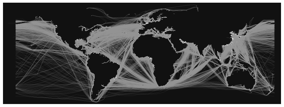
fig, ax = ox.plot_graph(G, figsize=(12, 14), node_size=0.5, edge_linewidth=0.1)
