Estimating Population Density based on Mobility Data#
Population density maps provide valuable insights into how people move and where they congregate, which is crucial for resource allocation and for public policy planning.
Important
This documentation outlines an experimental and exploratory process of creating such maps using mobility data. While this approach may address data scarcity, offer timeliness and other advantages, the results are not exempt from important Limitations.
Data#
To create population density maps based on mobility data, we will need access to the following data sources:
Area of Interest#
In this explotatory analysis, we employ the Lebanon’s subnational administrative boundaries maintained by UNOCHA Middle East and North Africa (ROMENA) on the Humanitarian Data Exchange.
Show code cell content
LBN = geopandas.read_file(
"../../data/shapefiles/lbn_adm_cdr_20200810/lbn_admbnda_adm3_cdr_20200810.shp",
crs="EPSG:4326",
)
Mobility Data#
Through the Development Data Partnership, the project team obtained a longitudinal panel of human mobility data. The panel consisted of anonymized timestamped geographical points generated by GPS-enabled devices, located in Lebanon spanning the period between August 1, 2023 to August 31, 2023..
The mobility data panel was provided pro-bono by Veraset to the proposal Understanding Lebanon’s Economy through Alternative Data through the Development Data Partnership. During the project’s execution, Veraset Movement’s global daily data feed was ingested and processed through the Geolocation Data Pipeline maintained by the Development Data Partnership. For additional information, please refer to the Mobility Documentation accessible to all World Bank staff.
Show code cell content
ddf = dd.read_parquet(
"../../data/interim/panels/v2023.9.4",
filters=[("country", "=", "LB"), ("month", "=", 8)],
dtype_backend="numpy_nullable",
);
At a preliminary level, let’s assess the data quality. First, let’s calculate the total number of observations and number of devices (sample size).
'Number of observations: 28,731,921'
'Number of devices (sample size): 51,893'
Also, let’s check for data quality. While insufficient, a visual inspection may provide a partial insight on the spatial distribution and skewness of the mobility data panel.
Show code cell source
DENSITY_PINGS_WEEK = (
ddf.groupby(["hex_id", "week"])["uid"]
.nunique()
.to_frame()
.groupby("hex_id")["uid"]
.mean()
.to_frame("count")
.compute()
)
DENSITY_PINGS_WEEK["geometry"] = DENSITY_PINGS_WEEK.index.map(
lambda x: Polygon(h3.h3_to_geo_boundary(x, True))
)
Weekly average device count in Lebanon at H3 resolution 7 in August 2023. Source: Veraset Movement.
Population#
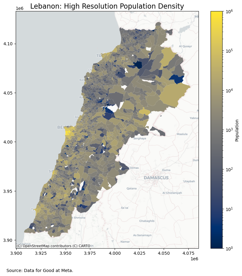
Accurate population data for the region of interest is essential. This can be obtained from census data or population estimates. Since its release, Since its release, Data for Good at Meta’s High Resolution Population Density Maps have seen an explosion of applications in the context of humanitarian aid and global development.
Show code cell source
POPULATION = pd.read_csv(
"../../data/external/highresolutionpopulationdensitymaps/2023/population_lat_30_lon_30.csv",
)
# Converting to `geopandas.GeoDataFrame`,
POPULATION = geopandas.GeoDataFrame(
POPULATION,
geometry=geopandas.points_from_xy(
POPULATION["longitude"],
POPULATION["latitude"],
crs="EPSG:4326",
),
)
Aggregating on administrative boundaries (level 3),
population = geopandas.GeoDataFrame(
POPULATION.sjoin(LBN, predicate="within")
.groupby(["admin3Pcod"])["population"]
.sum()
.to_frame()
.merge(LBN, on="admin3Pcod"),
geometry="geometry",
crs="EPSG:4326",
)
Plotting the population density map,
Methodology#
This exploratory methodology consists of estimating a population density based on a human mobility data panel. In other words, we aim to estimate the population density based on enumerating significant locations (e.g., home and work locations) of GPS-enabled devices staying put in each area and for each time period.
Implementation#
The following steps detail the process of generating population density maps based on mobility data:
Spatial Aggregation: Divide the area of interest into smaller spatial units (e.g., grid cells or administrative regions).
Temporal Aggregation: Aggregate mobility data over a specific time period (e.g., hourly, daily, or monthly).
Stay and Significant Locations Estimation: Estimate stay and significant locations based on how long and how often a device stays put in a certain area during a certain period.
Population Weighting: Multiply normalized mobility data by population data to get population-weighted mobility.
Computing Stay Locations#
To estimate stay locations (or “stops”), we employ the method introduced in [Hariharan and Toyama, 2004]. As described in the algorithm, we choose \(\Delta t=10\) (stay duration in minutes) and \(\Delta l=200\) (roaming distance in meters).
stay_locations_kwds = {
"minutes_for_a_stop": 10.0,
"spatial_radius_km": 0.2,
"no_data_for_minutes": 600,
}
As for the implementation, we leverage mobilkit and scikit-mobility, including built-in data structures skmob.TrajDataFrame and skmob.FlowDataFrame to analyze the mobiltiy data panel and determine stay locations and significant locations.
Now, we will compute the stay locations,
STOPS = mk.spatial.findStops(
ddf,
tesselation_shp=None,
filterAreas=False,
stay_locations_kwds=stay_locations_kwds,
)
Please note Dask uses lazy evaluation. The computations will not take place until until the data is exported. Before exporting, we partition the stay locations on each date.
STOPS["date"] = STOPS["datetime"].dt.floor("1d").dt.strftime("%Y-%m-%d")
Finally, we persist the results.
STOPS.to_parquet(
"../../data/results/stops",
compression="gzip",
write_index=False,
partition_on="day",
overwrite=True,
)
Mapping Stay Locations#
In this step, we aim to visualize and visually inspect the stay locations obtained the in the previous step. To start, let’s see how many stay locations were estimated.
'Number of locations: 1,179,442'
Let’s visually inspect a small sample (\(1\%\)) of the estimated stay locations. Please note that we conceal the device identifier and the observation’s date and time to protect privacy.
stops = STOPS[["lat", "lng"]].sample(frac=0.01).compute()
Show code cell source
geopandas.GeoDataFrame(
stops,
geometry=geopandas.points_from_xy(stops["lng"], stops["lat"]),
crs="EPSG:4326",
).explore(
marker_kwds={"marker_type": "circle_marker", "fill": False, "radius": 1},
style_kwds={"color": "red", "opacity": 0.5},
)
Alternatively, let’s visualize the daily average count of stay locations at H3 resolution 7.
STOPS["hex_id"] = STOPS.apply(
lambda x: h3.geo_to_h3(x["lat"], x["lng"], 7), axis=1, meta=("hex_id", "string")
)
And computing the daily average count of stay locations. And mapping,
DENSITY_STOPS = (
STOPS.groupby(["hex_id", "date"], observed=True)["uid"]
.count()
.to_frame()
.groupby(["hex_id"], observed=True)["uid"]
.mean()
.to_frame("count")
.compute()
)
Show code cell source
DENSITY_STOPS["geometry"] = DENSITY_STOPS.index.map(
lambda x: Polygon(h3.h3_to_geo_boundary(x, True))
)
geopandas.GeoDataFrame(DENSITY_STOPS, geometry="geometry", crs="EPSG:4326").explore(
column="count",
cmap="YlOrRd",
scheme="FisherJenks",
k=9,
legend_kwds={"max_labels": 3},
style_kwds={"fillOpacity": 0.75},
)
Daily average number of stay locations in August 2023 at H3 resolution 7 in Lebanon. Source: Veraset Movement.
Computing Significant Locations#
In this step, we compute and map significant locations. Significant locations are signicant stay locations, e.g., home or work locations. Particularly, we will select (sample) estimated residential locations to impute a population density.
The “home” location is determined as the most frequent location where a device stayed put during night hours (by default, between 21:00 to 7:00 local time). We also compute the \(\delta_h\) fraction of home-hours for which the single location is the most visited one.
LOCATIONS = mk.spatial.computeUsersLocations(
STOPS,
method="dbscan",
link_dist=100,
min_stops_count=1,
return_locations=False,
)
Additionally, we enrich LOCATIONS with additional statistics. For instance, total number of days a device is seen at the estimated home (or work) location.
LOCATIONS = mk.stats.stopsToHomeWorkStats(SIGNIFICANTLOCATIONS, force_different=False)
Finally, we select those locations with at least \(\delta_h \ge 0.5\).
locations = LOCATIONS[(LOCATIONS["isHome"]) & (LOCATIONS["home_delta_count"] >= 0.5)]
'Number of eligible devices: 22,790'
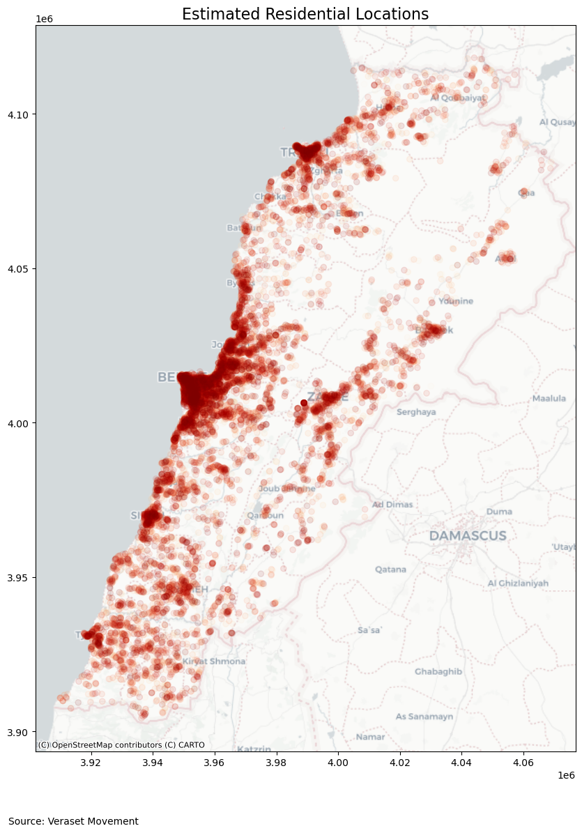
Mapping Signicant Locations#
In this step, we map significant locations. In particular, the estimated residential locations. Converting to geopandas.GeoDataFrame,
Show code cell source
fig, ax = plt.subplots(figsize=(10, 20))
ax = locations.to_crs("EPSG:3857").plot(ax=ax, cmap="OrRd", alpha=0.1)
plt.title("Estimated Residential Locations", fontsize=16, ha="center")
subtitle_text = "Source: Veraset Movement"
ax.text(-0.05, -0.1, subtitle_text, transform=ax.transAxes, fontsize=10, ha="left")
cx.add_basemap(ax, source=cx.providers.CartoDB.Positron)
Now, let’s transform the locations into a density. Thus, we aggregate the number of home locations into a population density at administrative boundaries.
DENSITY_LOCATIONS = geopandas.GeoDataFrame(
locations.sjoin(LBN, predicate="within")
.groupby(["admin3Pcod"])["uid"]
.count()
.to_frame("count")
.merge(LBN, on="admin3Pcod"),
geometry="geometry",
crs="EPSG:4326",
)
In summary, we will present the Estimated Residential Locations and Estimated Residential Locations (log) in logarithmic scale.
DENSITY_LOCATIONS["Estimated Residential Locations"] = DENSITY_LOCATIONS["count"]
DENSITY_LOCATIONS["Estimated Residential Locations (log)"] = np.log10(
DENSITY_LOCATIONS["count"]
)
And finally mapping,
DENSITY_LOCATIONS[
[
"Estimated Residential Locations",
"Estimated Residential Locations (log)",
"geometry",
]
].replace([np.inf, -np.inf], np.nan).dropna(subset="geometry").explore(
column="Estimated Residential Locations (log)",
cmap="viridis",
style_kwds={"weight": 0.25},
legend_kwds={"max_labels": 5},
vmin=1,
vmax=DENSITY_LOCATIONS["Estimated Residential Locations (log)"].max(),
)
Estimated (Sample) Residential Density in Lebanon. Source: Veraset Movement.
Comparing to High Resolution Population Density Maps#
We compare the estimated (sample) population density obtained in the previous steps to the population estimates provided by Data for Good at Meta.
COMPARISON = (
pd.merge(
population,
DENSITY_LOCATIONS[["admin3Pcod", "count"]],
how="left",
on="admin3Pcod",
)
.set_geometry("geometry")
.to_crs("EPSG:3857")
)
Comparing Density and Sampling Rate#
To compare, we compute a sampling rate. In other words, we compute the ratio of the estimated home locations density and the population estimates.
COMPARISON["Sampling Rate (%)"] = 100 * np.round(
COMPARISON["count"] / COMPARISON["population"], 4
)
Additionally, we compute the approximate population density (inhabitans per square kilometer).
COMPARISON["area"] = COMPARISON["geometry"].area / 10**6 # square km
COMPARISON["population_density"] = COMPARISON["population"] / COMPARISON["area"]
Show code cell source
output_notebook()
source = ColumnDataSource(COMPARISON.drop(["geometry"], axis=1))
p = figure(
tools="pan,wheel_zoom,box_zoom,reset,hover",
x_axis_type="log",
y_axis_type="log",
# x_range=[1, 10**6],
y_range=[1, 10**3],
title="Estimated Home Locations/Population in Lebanon",
)
p.xaxis.axis_label = "Population"
p.yaxis.axis_label = "Estimated Home Locations (Mobility Data)"
hover = p.select(dict(type=HoverTool))
hover.tooltips = [
("admin1Name", "@admin1Name"),
("admin3Name", "@admin3Name"),
("Estimated Homes", "@count{0,0}"),
("Population", "@population{0,0} (inhabitans)"),
("Population Density", "@population_density{0,0} (inhabitans per square Km)"),
]
color_mapper = LogColorMapper(
palette="Magma256",
low=min(COMPARISON["population_density"]),
high=max(COMPARISON["population_density"]),
)
s = p.scatter(
"population",
"count",
source=source,
size=7,
color={"field": "population_density", "transform": color_mapper},
)
color_bar = s.construct_color_bar(
title="Density (inhabitans per square kilometer)",
padding=5,
ticker=p.xaxis.ticker,
formatter=p.xaxis.formatter,
)
p.add_layout(color_bar, "right")
p.legend.location = "top_left"
p.legend.click_policy = "hide"
show(p)
And mapping the sampling rate,
Show code cell source
COMPARISON[
[
"Sampling Rate (%)",
"count",
"population",
"geometry",
"admin1Name",
"admin3Name",
]
].explore(column="Sampling Rate (%)", cmap="PuBuGn", scheme="FisherJenks")
Above we present the sampling rate (%) based on the ratio of estimated residential locations and population density estimates for each area. Source: Data for Good at Meta, Veraset Movement.
Findings#
The mobility data panel contains \(28731921\) observations. Even though the volume of observations is significant, the panel contains \(51893\) devices only.
The mobility data panel shows evidence of sample bias and spatial skewness, presenting higher density in affluent and urban areas compared to rural areas.
This exploratory study determined potential \(22790\) residential locations in Lebanon. However, this represents ~\(44\%\) (\(22790\) out of \(51893\)) of the sample population or less than \(0.5\%\) of the estimated national population in Lebanon (World Bank, 2022).
This exploratory study, however limited, demonstrated a methodology to create population density maps. While this approach may address data scarcity, offer timeliness and other advantages, the results are not exempt from important Limitations.
Show code cell source
fig, (ax1, ax2) = plt.subplots(1, 2, figsize=(20, 10))
ax1.axis("off")
ax2.axis("off")
DENSITY_LOCATIONS.to_crs("EPSG:3857").plot(
ax=ax1,
column="Estimated Residential Locations",
cmap="viridis",
norm=matplotlib.colors.LogNorm(vmin=1, vmax=10**3),
vmin=1,
legend=True,
legend_kwds={
"label": "Estimated Residential Density",
},
)
ax1.set_title("Lebanon: Estimated Residential Density", fontsize=16, ha="center")
cx.add_basemap(ax=ax1, source=cx.providers.CartoDB.Positron)
population.to_crs("EPSG:3857").plot(
ax=ax2,
column="population",
cmap="cividis",
norm=matplotlib.colors.LogNorm(vmin=1, vmax=10**6),
vmin=1,
legend=True,
legend_kwds={
"label": "Population",
},
)
ax2.set_title("Lebanon: High Resolution Population Density", fontsize=16, ha="center")
cx.add_basemap(ax=ax2, source=cx.providers.CartoDB.Positron)
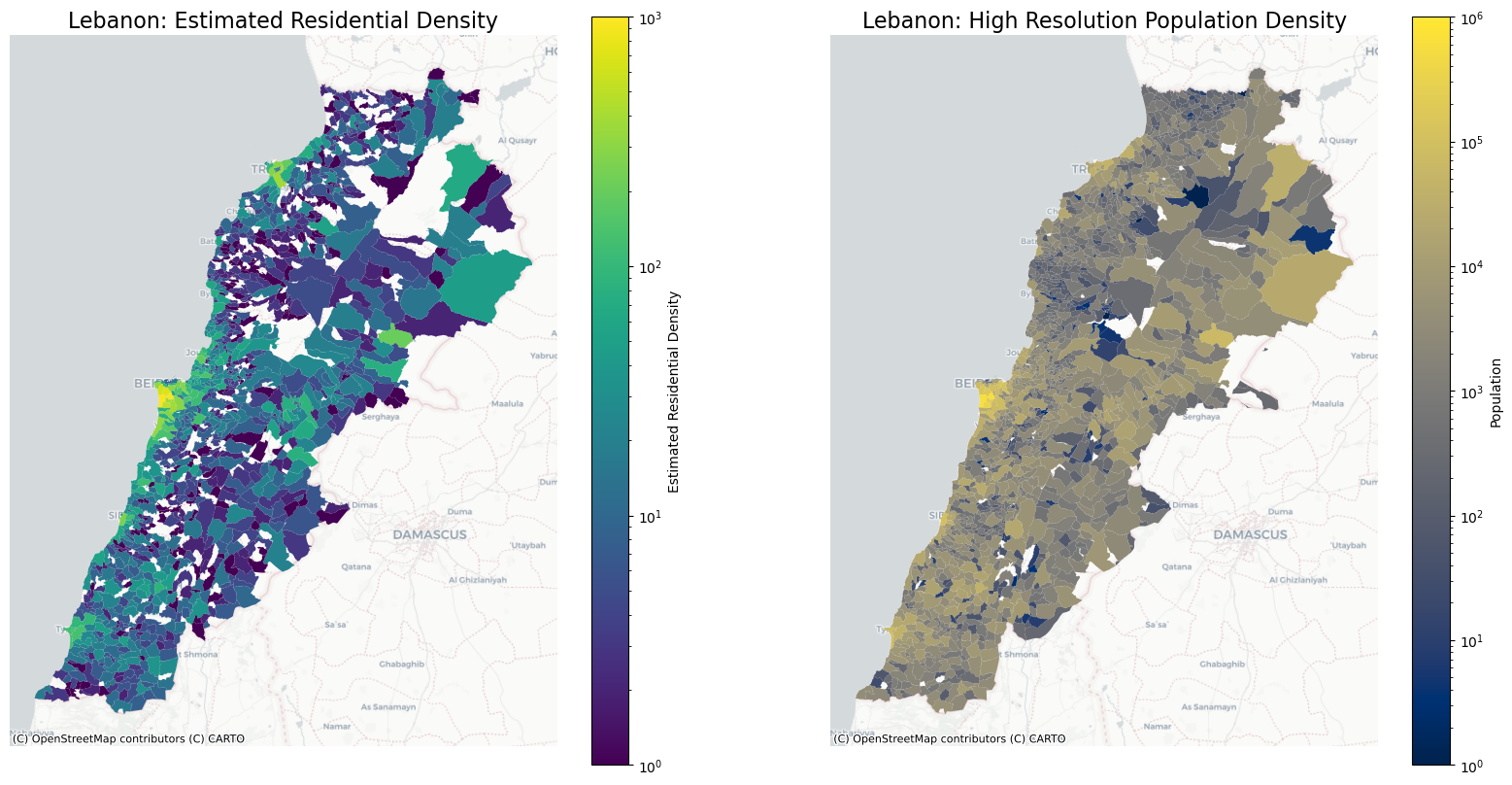
Comparison between Estimated Residential Density (based on Mobility Data) and Data for Good at Meta’s High Density Population Maps for August 2023 in Lebanon. Source: Project team estimates.
Limitations#
Caution
Sample Bias: The sampled population is composed of GPS-enabled devices drawn out from a longituginal mobility data panel. It is important to emphasize the sampled population is obtained via convenience sampling and that the mobility data panel represents only a subset of the total population in an area at a time, specifically only users that turned on location tracking on their mobile device. Thus, derived metrics do not represent the total population density.
Incomplete Coverage: Mobility data is typically collected from sources such as mobile phone networks, GPS devices, or transportation systems. These sources may not be representative of the entire population or all economic activities, leading to sample bias and potentially inaccurate estimations.Not all individuals or businesses have access to devices or services that generate mobility data. This can result in incomplete coverage and potential underrepresentation of certain demographic groups or economic sectors.
Lack of Contextual Information: Mobility data primarily captures movement patterns and geolocation information. It may lack other crucial contextual information, which are essential for accurate estimation of population movement.
References#
- HT04
Ramaswamy Hariharan and Kentaro Toyama. Project Lachesis: Parsing and Modeling Location Histories. In Geographic Information Science. Volume 3234, volume 3234, 106–124. 2004. doi:10.1007/978-3-540-30231-5_8.