Conflict in Niger Analysis from ACLED Data#
Data#
Overview of ACLED Data#
The Armed Conflict Location and Event Data (ACLED) is a disaggregated data, which reports information on conflict events in every country and territory in the world. It encompasses data on the type, agents, date, location and other attributes of demonstration events, political violence events, strategic developments, and other non-violence politically-relevant developments at specific points in time. The data is collected in real-time and published on a weekly basis.
Methodology#
Background of work#
Following the coup in Niamey on 07/26/2023, we would like to understand the trend of reported conflict events over time in Niger. For this analysis, ACLED data is downloaded for a 5-year period (2019-present), however the primary focus is on 2022-2023.
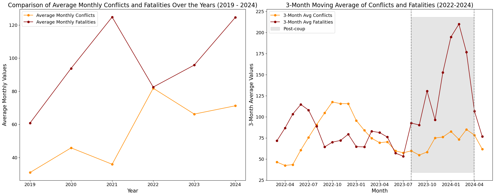
1). Average monthly conflict and fatalities over the years#
The recorded data from January 1, 2019, to May 15, 2024, clearly shows that aside from the peak in average monthly conflicts in 2022, the average monthly conflict occurrences and consequent fatalities in Niger worsened after the coup in 2023. In 2024, the average fatalities per month have already tied with 2021 for the highest at 125, and the average conflicts per month are the second-highest at 71 within just five months.
To fully reveal the extent of the spike in conflicts and fatalities post-coup, between the years 2022 to 2024, we observe a 3-month moving average where we clearly see that fatalities increased more rapidly than conflict occurence.
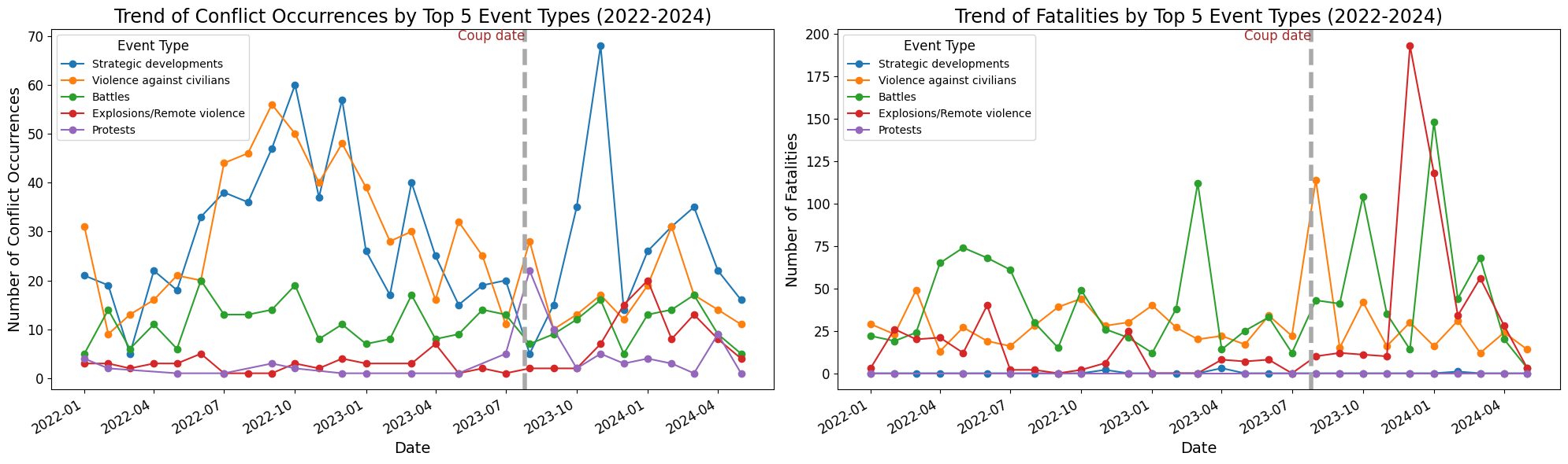
2). Conflict Occurence by top 5 Event types (2022 - 2024)#
Before the coup, “strategic development” conflict events and “violence against civilians” consistently dominated other event types such as “battles,” “explosions/remote violence,” and “protests.” Notably, after the coup, specifically in November, there was a clear spike (an all-time high for the years under consideration), in the total number of conflicts attributed to “strategic developments.”
This spike was likely triggered by the French president’s announcement on September 24, 2023, regarding the withdrawal of troops and diplomatic staff, including Ambassador Sylvain Itte. He highlighted that the full withdrawal of the 1,500 French troops stationed in the country was expected by the end of the year.
Immediately following this spike in strategic development conflict events, there was another all-time high in the number of fatalities caused by “explosions/remote violence.” In the following month, fatalities caused by “battles” surpassed those from other events. It is important to note that “battles” have generally been the leading cause of fatalities over the years, except during the period around the coup, when “violence against civilians” was responsible for the highest fatalities and conflicts.
(a). All Conflicts#
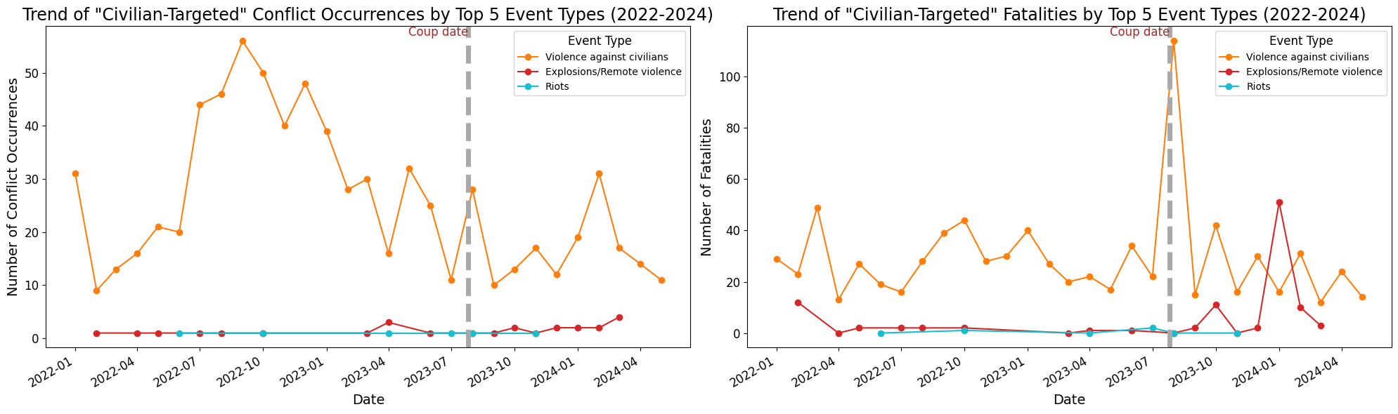
(b). Civilian-targeted conflicts#
For civilian-targeted events, “Violence against civilians” was the dominant event type for both fatalities and conflicts. A spike in fatalities caused by “explosions/remote violence” was observed around February 2024.
3). Heatmap to show conflict and fatality occurences over past 2 years#
Between January 2022 and May 2024, the country experienced the most conflict events in October 2022, with 136 events resulting in 96 fatalities. However, the highest number of fatalities occurred in January 2024, with 283 fatalities from 84 conflicts, followed by December 2023, with 237 fatalities from 49 conflicts. These relatively high fatality numbers were observed post-coup.
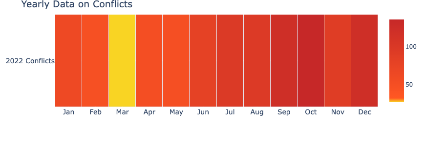
Fig. 1 Yearly Data on Conflicts#
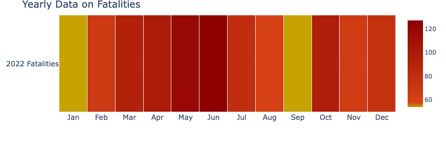
Fig. 2 Yearly Data on Fatalities#
4). Calculating Conflict Index#
Conflict Index is calculated as a geometric mean of conflict events and fatalities at admin 2 level
Note
Geographical overview of Niger
Niger is divided into seven regions (Agadez, Diffa, Zinder, Maradi, Tahoua, Tillabéri, and Dosso), each named after its capital. Additionally, there is Niamey, the national capital, which comprises a capital district.
Using the 2020 census data, the map below shows that Niamey, the capital district, is the most densely populated region, with approximately 3,601 persons per square kilometer. Maradi and Dosso follow, with densities of 115 and 85 persons per square kilometer, respectively. Tahoua, Tillabéri, and Zinder have moderate population densities of 41, 40, and 32 persons per square kilometer, respectively. In contrast, Diffa and Agadez have very low population densities, with 5 and 1 person per square kilometer, respectively.
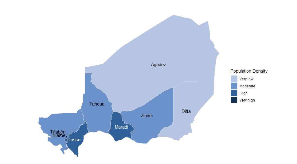 Population density of the 7 regions and capital district in Niger
acled_22 = get_acled_conflicts_by_year(acled, "2022-01-01", "2022-12-31")
acled_23 = get_acled_conflicts_by_year(acled, "2023-01-01", "2023-12-31")

5). Geospatial changes in conflicts (2022 - 2023)#
Cumulatively, total conflict events dropped by at least \(100\) between 2022 and 2023, while a spike in the number of recorded fatalities was observed.
The Tillabéri region, followed by the Diffa region, appears to be the most impacted across the years. An uptrend is observed for Tillabéri, which recorded the significantly highest average conflict index (CI) of \(40.59\) in 2023 (the year of the coup).
The average CI in Diffa dropped to \(12.31\) in 2023 from \(15.39\) in 2022.
The average CI in Tahoua region dropped from \(7.89\) in 2021 to \(4.31\) in 2022. This number only increased slightly to \(4.67\) in 2023.
These high average CIs in the Tillabéri region are mainly seen in Abala, Tillabéri and Téra departments or sub-regions.
In the “Conflict Index by Admin 1” line graph, we also see that Tillabéri consistently recorded the highest conflict index of at least \(20\) throughout the year, with a spike above \(80\) in January 2024. The only exception to this trend occurred between March and April 2023 (before the coup), when Diffa’s conflict index spiked above \(55\) (the highest across the regions). This may be due to violence from Boko Haram in Nigeria, as Diffa is a common destination for refugees fleeing the violence, as previously reported by the International Rescue Committee in 2014.
Conflict occurrences and fatalities in the Diffa region are concentrated in the southeastern part, covering the Diffa, Bosso and N’Guigmi sub-regions.
From January 2019 to May 2024, Niamey capital district mostly maintained a conflict index of \(0\), with occasional spikes between \(1\) and \(3\). Notably, there was one spike above 2 occurring around the coup date.
The Agadez region experienced a high number of conflict events in 2022 and 2023, but with very few fatalities, leading to relatively low average CIs compared to the Maradi region.
The Dosso and Zinder regions consistently experienced fewer conflict occurrences and fatalities across the years (2019-2023).
In summary, the impact of the Niamey coup on July 26, 2023, in terms of the intensity of conflicts and consequent fatalities, measured by the average annual conflict index, was mostly observed in the Tillabéri region, which surrounds Niamey.
a). Average conflict index by Admin 1 (Regions) in each year (2019 - 2023), to determine the intensity of conflict occurence and consequent fatalities.#
b). Average conflict index by Admin 2 (Departments) in each year (2019 - 2023), to determine the specific areas (departments) in the region responsible for the observed intensity of conflict occurence and consequent fatalities.#
c). Top 5 worst affected admin 1 regions in 2022#
| event_date | ADM1_FR | fatalities | event_id_cnty | |
|---|---|---|---|---|
| 6 | 2022-12-31 | Tillabéri | 592 | 357 |
| 1 | 2022-12-31 | Diffa | 251 | 159 |
| 0 | 2022-12-31 | Agadez | 33 | 156 |
| 3 | 2022-12-31 | Maradi | 41 | 139 |
| 5 | 2022-12-31 | Tahoua | 49 | 96 |
d). Top 5 worst affected admin 1 regions in 2023#
| event_date | ADM1_FR | fatalities | event_id_cnty | |
|---|---|---|---|---|
| 6 | 2023-12-31 | Tillabéri | 738 | 383 |
| 1 | 2023-12-31 | Diffa | 224 | 127 |
| 5 | 2023-12-31 | Tahoua | 95 | 76 |
| 3 | 2023-12-31 | Maradi | 31 | 70 |
| 0 | 2023-12-31 | Agadez | 30 | 54 |